


04 de December de 2020
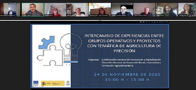
December 4, 2020. The Ministry of Agriculture, Fisheries, and Food (MAPA) has organized a day of experience sharing between operational groups and innovative projects on precision agriculture. Precision agriculture is a management strategy that collects, processes, and analyzes data and combines it with other information to improve the efficiency of agricultural production. This requires a set of technologies based on sensors and both satellite and aerial images to capture crop variations.
- The MAPA has organized a meeting between Operational Groups and Innovative Projects on precision agriculture.
- During the meeting, participants were able to exchange knowledge about the use of new technologies in agriculture, such as remote sensing, artificial intelligence, Big Data, drones, and robotics.
The information collected is used to more accurately determine planting density, estimate the appropriate amount of fertilizer or other necessary inputs (seeds, pesticides, etc.), and more accurately predict crop yield and production.
Virtual day
During the meeting—attended by 340 registered participants — innovative measures in rural development programming were presented, and the Framework Programme was emphasized as the EU's main instrument for supporting research and innovation. The importance of the Soil Health and Food Mission in maintaining healthy soils was also explained.
Thematic blocks
Six regional and national Operational Groups and Innovative Projects were presented at the exchange. Participants shared initiatives, results, progress, and experiences in precision agriculture, focusing on three themes:
Block 1: Remote sensing
- Participants: “ AGROTIG ”: development of a web-based mapping server for monitoring cereal crops by remote sensing” and “ APOLLO ”: development of a commercial platform for agricultural advisory services based on free and open access Earth observation data.
- Papers and Conclusions: Among the challenges posed, it was highlighted that precision agriculture requires low-cost services and technologies that are easy to implement for technicians and farmers. The importance of promoting R&D&I projects that consider the co-creation of products and services with users was emphasized.
Block 2: Artificial Intelligence and Big Data
- Participants: “ RECOLECTA ”: prediction of the optimal harvesting time through comprehensive thermal management of crops” and “ BIHORTAFLOR ”: applying artificial intelligence and big data solutions to improve the economic and environmental efficiency of agricultural holdings.
- Papers and conclusions: The importance of giving a second life to data, both data collected by producers and data obtained through new technologies (sensors, satellites, and meteorology), to solve specific problems (e.g., determining the optimal time to harvest with maximum quality in advance). It was also highlighted how the incorporation of new technologies into agriculture contributes to improving water use and consumption, as well as farm profitability.
Block 3: Drones and robotics
- Participants: “Integration of multispectral and agroclimatic data obtained through drones and satellite images in vineyard management for decision-making in viticulture” and “ SMART AKIS: GIS ”, precision agriculture, and agricultural automation and robotics.
- Papers and Conclusions: This section highlighted the importance of multispectral image data, which, combined with climatic, soil, and agronomic variables collected by drones, allows for improved crop management and monitoring. It was also emphasized that it is important to demonstrate the benefits of smart agriculture, innovate business models, ensure broadband connectivity in rural areas, develop user-friendly solutions and promote interoperability standards, create a transparent framework for the use of generated data, introduce smart agriculture into education and training of technicians, and strengthen the role of impartial (non-commercial) advisors in digitalization.
What is innovation?
Innovation is an essential tool for achieving a sustainable and competitive agricultural and forestry sector within Europe. In the area of agriculture and rural areas, in accordance with the Europe 2020 Strategy and the general objectives of the Common Agricultural Policy, innovation is considered an essential cross-cutting priority for achieving the objectives of European rural policy.
All the information about this event can be found on the website, as well as on the National Rural Network's social media channels: Twitter, Facebook, and YouTube, where you can enjoy this event openly.